
This post was written on October 3rd and posted on October 4th.
Things do not always work out as planned. During the night in Queyrieres, something that I had eaten, whether that day or previously, decided to take its revenge. Let’s just say that I spent a considerable amount of time on the toilet, and when I woke in the morning, I felt a mixture of hunger, apprehension, and a lack of readiness to face the day ahead.
My hosts of the evening are both early risers, and depart for their jobs relatively early in the morning. They had left out a breakfast for me. I arose early enough for me, ate the breakfast, prepared my things, and got ready for the road.
I had decided that I wanted to see a bit more of Queyrieres, and in particular whether it was possible ascend the basalt tor in the middle of the village. But when I awoke, the weather gods had other ideas. It was raining when I left the house, and I did no more than walk around the village before heading out on the trail. And yes there is a public access to the route to ascend the basalt tor, but in the gloom and mist of the day, I decided to forego that and push on. This was real rain this morning. Not the condensing mist that I dealt with yesterday, but instead a steady drizzle.


I reckon part of the reason it was raining is due to the height. Queyrieres is at about 1150 matters above sea level, and by the time I had descended to the village of Monedeyres, things had improved considerably. I could see the sun coming through the clouds in the west, with the promise of a better day ahead. But the weather, like fate, can be a tempter. Sometimes the weather seems to look kindly on us mortals to encourage us to do something we should not. And at other times, it seems intent on dissuading us from something we really want to do. And so it was today. It was as if the weather had been trying to dampen my determination to complete this last day. Shortly after Monedeyres, I took off the raingear, though I kept it ready to use again.
A while after Monedeyres, the trail splits in two. What the book calls the classic GR65 continues south, and winds around to enter St-Julien Chapteuil from the south. The alternative is a direct route to that town, entering from the north. The northern route seems to be the most popular, with the bootprints of many previous walkers. At times, the waymarking was uncertain, and I was indebted to the local schoolchildren who had placed scallop shells, sometimes brightly coloured, at critical points to show the way.


The route through St-Julien-Chapteuil takes one through back alleys and lesser streets to eventually emerge on the road west. It was starting to rain again as I came into St-Julien-Chapteuil, so I went into a café for a warm coffee, and by the time I came out, the rain had stopped. The route out of town follows the road, but then diverges to go back into the countryside. It goes through Eynac, Tournecol and Marnhac before turning south to reach the main road leading into St-Germain-Laprade, Coming into Eynac, it seemed the rains were starting again, but by the time I was through the village, the threat had receded, albeit briefly. I mentioned yesterday who I had seen less of “martins long way” in the last day or two, but I came across the stickers again today on the way into both St-Julien-Chapteuil and St-Germain-Laprade.

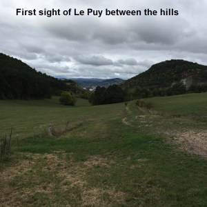
Coming into St-Germain-Laprade, the rain started again, but in the park there were covered picnic benches, so it seemed like a good place to have lunch. And sure enough, the rain stopped while I was snacking. I left St-Germain-Laprade and headed up the hill. On the crest, just visible between two basalt hills, I caught a glimpse of Le Puy en Velay. Dorothy, seeing the Emerald City for the first time could not have been more delighted. Journey’s end was close at last. And so I continued downhill into Brives-Charensac. I seemed to be moving faster as my journey’s end came nearer. I had thought of stopping in Brives-Charensac, but there was no point now that I was so close to the end. I went on across the Loire. The Loire is a mighty river, but here it was just the infant version of what it would become further downstream. Crossing the bridge to the west bank, I felt that I was almost there, even though the signs told me that I still had five kilometers to go to Le Puy itself. Soon enough the track left the riverside, and following around under a railway bridge, I came to the official signs telling one that one is entering Le Puy.


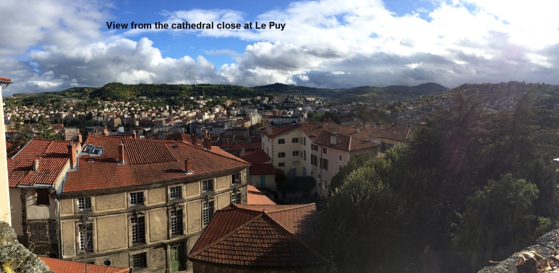
And so I made my way to the city centre. First to the hotel, where I dropped off my stuff, freshened up, and so on. And then to the cathedral. Le Puy has a real cathedral, not just a remnant of a bygone age, but a real functioning cathedral. I spent a while there, thinking of the journey that I had done, and what still remains. As I stood in the cathedral close, looking down towards the city, I could not help feeling that somewhere out there is Luzern where I started. Somewhere out there too is Santiago, with many days walking to get there. I will come back to Le Puy in 2018 to do the next stage of the journey.


To celebrate the completion of this walk, I went for dinner. Now it is time to return to Basel, to reflect on this walk, and to prepare for the next stages.
